Sunday, 3 August 2014

Day 8 Keld to Reeth GPS 118 miles

We had a good night last night with some great company, we have bumped into Steve, Joe and Laurie a few times as they are coast 2 coasting a similar schedule to us and last night we were the last to leave the bar, also talked with a great couple, Bill and Denise who have made a donation to our chariity.    

Today we checked the weather forecast and it didn't look good. We started in the rain and kitted out in full wet gear. 
This walk so far has been all highs but first thing today was a bit of a low. Kirsty had jarred her knee on a step (not on the walk but just in the village-typical!) and was quite upset as she was really struggling down any type of hill. But Kirsty is a warrior and will soldier on regardless, we might walk slower but we will get there. Fortunately we have a fairly easy terrain today.
The beggining of the walk we saw many waterfalls.
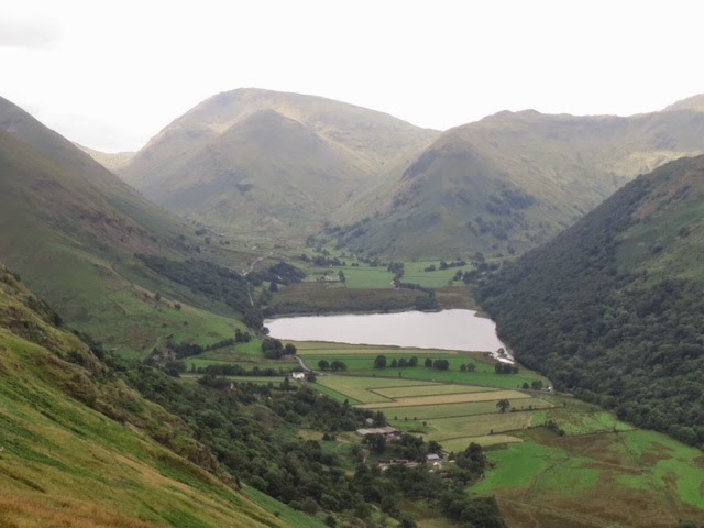
And as we climb slightly we cast our eyes on the valleys with the masses of dry stone walls and neat hay barns.
We found an abandoned tractor that must have been there a hundred years.

    The closest I have been to transport for 8 days.

Soon the weather improved and we managed to stay dry for the rest of the day and finished in sun, This walk was at a leisurely pace and due to the shorter nature of this leg we decided to take a detour off the path to the village of Muker, this village is a joy to see. It is a very pleasant little place and one of James Herriot's favourites.
 Muker Church
Our route now follows the river and passes through some lovely villages many still having the bunting left up from the Tour de France, as it passed through a few weeks ago.
             Ivelet display
We ate lunch by the river 

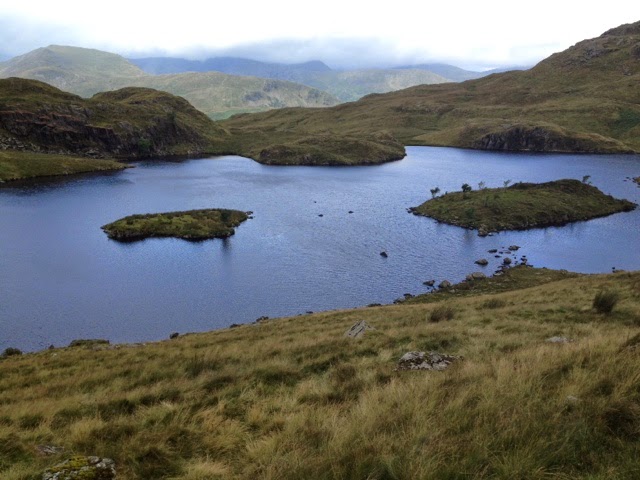
Soon we were climbing again and we had great views of Swaledale from open moorland.
 
And as we reach the track that took us towards the hamlets of Blades, Kearton and Healaugh we still had great views and now the sun was out. 
We then followed the road for a short while passing this bad boy in a field.
      So glad we didn't have to walk through his field.
 The final section of todays walk, along the river Swale on to Reeth, led us past the new swingbridge rebuild after the floods of 2000.

We arrived in Reeth, an archetypal Yorkshire dales village flanked to the North and South by valleys and ringed by dry-stone walls. At it's heart lies a village green surrounded on all sides by gift shops, pubs and tea rooms. Where tonights meal was at the Black Bull and we bumped in to Joe, Steve and Laurie again and also a great couple Andy and Janine who again we have talked to several times, they are always smiling as long as Andy doesn't miss his tea break.
A great days walk and hoping the body parts hold out tommorrow.
So proud of Jane and Kirsty battling sore knees and feet all for Cancer research so Please keep the comments and donations coming it is most apreciated.

Saturday, 2 August 2014

Day 7 Kirkby Stephen - Keld 103 miles

Keld Marks the half way point of our coast to coast walk and this is one of our shortest days, and wettest so far.
This short day just 12 miles begins in dry conditions but as we walked uphill from the start we could see threatening rain clouds where ever we looked. But the views were pleasing to the eye.
As we took on a tough 4 mile uphill journey over the Pennine Mountains Kirsty found a great seat to rest her legs.

Here we were still in warm dry weather but as we reached the the sign post where you have to decide if you want to climb to the Nine standards or not, the weather started to close in. The cloud was on top of the mountain but nothing was stopping us and Steve was confident of being able to navigate  so off we trotted. As we approached the 9 Standards they seemed to suddenly jump out the mist.
 Soon we reach the top of the mountain line where the 9 Standards are. The 9 Standards are just a series of man made rock cairns all in a line, pretty cool, but no one seems to know why they are here.
 
And we are not the only ones up there so we manged to get a team photo.
 We then walked to the trig point  and on to the sign post that shows the different routes for different times of the year to reduce erosion
Moving the sign might help erosion or even some stone slabs like they use in the peaks.
This is were it gets REALLY boggy. We had to take the slightly longer blue route that starts  in August, so it made navigation a little harder as it had not been used for some time and was not obvious. There were poles showing the way once you got going so not too much difficulty finding our way.
Now the heavens opened and we had torrential rain for quite a while, Steve decided to run straight into a boggy section up to his knees , much to the amusment of Jane and Kirsty and believe me bog smells terrible. From here we followed the posts all along Whitsundale beck.With it raining we were very lucky to find shelter for lunch.
   Our luxury dining suite!
From here we walked in torrential rain and hoped to get a cuppa at Ravenseat Farm but sadly it was closed.
From here we track along the engorged chasm of Whitsundale Beck
 we passed many fully restored but unused stone barns or 'laithes' which are a feature of Swaledale we soon reach the road and it is an easy walk into Keld. we pass the Wainwath force.

We reached the Keld Lodge, our accommodation for the night, in pouring rain and pretty much soaked, thank goodness for the drying room.
We are now halfway and our feet are holding up well. Jane and Kirsty are suffering slightly with painful knees but nothing to hold us back.

Friday, 1 August 2014

Day 6 - Shap to Kirkby Stephen 91 miles done


We set off early, in light rain, on what is our longest day so far. Last nights B&B was run by the most delightful lady, Margaret, who could not do enough for us. Brookfield house is the most welcoming place and we would recommend it to anyone. 
Margaret not only made us welcome she treated us like her own family. For our packed lunches she made us sandwiches, home made almond tarts and home made fruit cake that were  delicious along with a drink and crisps each. When we asked how much she said "Whatever you think it is worth put in  to our charity fund"  so we added 20 pound then we met two Americans in the hallway who donated another 20.
The start of todays walk was quit a shock after walking 5 days in total peace and virtual isolation we then meet the M6. we crossed on the footbridge.


We then walked alongside it for a short while by the cement works yuk!!!
The difference from yesterday when we had a beauiful climb in the hills  could not be more pronounced,
We had distance views of the Lakes and Kidsty Pike, where we were yesterday but this soon disappeared as it began to rain very heavy. After leaving the motorway we soon saw the change in geology with the limestone pavement.


With the weather now very wet we walked across many walled fields and over Tarn Moor. we did not take many photo's as it was too wet to get the camera out.
This shows you how wet,  Still nothing compared to what we know others have had and it looks like we will get more tomorrow. Still  Kirsty keeps us amused  with her humour like climbing stiles that are no longer there.

After hiding behind a wall for lunch  we set off on a long trudge in the rain to Smarldale where we traverse the bridge.

A little further on we spotted the Smardale viaduct.

Here it stopped raining just in time to bolster our spirits to finish todays long section. we moved on over the crest of Smardale fell where, the village of Kirkby could just be seen  and in the distance tomorrrows target the Nine Standards could be seen.
We finish the walk passing under an old railway and onto the centre of Kirkby 

We are now tired and arriving at Kirkby Stephen - the second biggest settlement on the  walk and our main objective is getting or boots off. We look forward to tomorrows trip  uo to Nine standards Rigg and on to Swaledale.
Sorry for the lack of pics but the rain stopped us taking many and no one aound to take a family picture.
Thanks for your comments!

Thursday, 31 July 2014

Day 5 Patterdale - Shap GPS 70 miles


We set of on todays trek with the weather dry but overcast, The Patterdale to Shap stage is said to be the toughest stage on the Coast to Coast, not because it has the most miles but because of the terrain. Although we left the Lake District today, it doesn't give up without a fight. We can only  say it is the hardest day yet and we hope that tommorrow is not as hard even though it is a longer day at 20 miles ish.
We left Patterdale and almost immediately started a very long ascent  The views just got better as we climbed.
     here you can see Brothers Water
It didn't matter where you looked the scenery was breathtaking. 
Here we got talking to some walkers from the USA who took our justgiving address and promised to pay us $100 when they returned home. Not sure of the exchange rate but this is a fantastic guesture from a couple of strangers.
We reached Angle Tarn a beautiful lake

It was here where we had this photo taken by a couple who we had met earlier and they also were walking c2c. They were sisters we neve asked their names so called them 'double top' as they wore the same colour tops.
 From here the gradient levels off for a short while until another tough haul gets us huffing and puffing as we climb to The Knott, but the panoramic veiws make it all worth the effort.
 I never tire of the scenery here.
After the Knott who's very name exudes a hikers challenge we then reach a point on the ridge where we turn left, it is here we turn to go towards Kidsty Pike, the veiws of Haweswater and High Street are stunning and while admiring the grandure of the whole outlook we spotted the 'Double Top' walking towards the peak of High Strret a lovely mountain but visiting it would me a massive diversion for any coast to coast walker so we got their attention to the wrong turn they made with a whisle. They caught us up on the top of Kidsty Pike and thanked us while taking another photo for us.
.
     On the summit of Kidsty it was a good ten degrees colder than the lower slopes.At his point we were at 2572ft. the highest point on the standard c2c route but we had been a lot higher by doing Helvellyn at 3113 ft yesterday. It was now just raining as we started our descent, what goes up must come down but this descent is much steeper than anyone would like and it really started to hurt our knees and feet, then the sun broke through  by the time we reach the Haweswater reservoir so we stopped here for lunch and to rest our feet.
We now have a four mile walk along the shores of Haweswater but a lakeside amble while spinning your dainty parasol it sadly is not, soon we are again panting like a hippo on a tread mill high above the shore.
Eventually after what seemed for ever we left the reservoir and we were out of the Lake district. We were a little upset that our journey across the lakes had finished because it is the most beautiful place but we will not miss the hard work involved in some of the climbs. 
The topography was now more of rolling hills than mountains.
 We passed over Rosgilll Bridge and just after Kirsty mentions she would love a Coke we had a total surprise in finding this.
     Wouldn't be there long in the                             Midlands!!!!!
We passed over a gate on top of a wall
          "why put that there?'
Eventually we trudged on past the ruins of Shap Abbey and on to Shap

On reaching Shap we were getting very, very tired but we had not realised we had a B&B  1 1/2 miles down the Main Street of Shap. We then had to walk back later to find a pub to eat in, for our evening meal.
Well we have 20+ miles to go to Kirby Stephen tomorrow so I must get some sleep. We have taken over a hundred photos each day  and to sort just a few out seems to take an age.
I must post this last photo as Andy Chales has promised to pay us 5 pounds for every bed Jane does not make. It is a long story but Jane will not leave a B&B without making the bed so this will be hard. We even explained this to the last owner and he laughed making the comment that she is mad no one makes the bed when they leave so for a fiver here it is.
Good night al land please keep the comments and donations coming it does drive us on.

Day 4 Grasmere to Patterdale. GPS reads 52 mles

Today we start with the weather looking grim. This is meant to have  been an easier day but, in the spirit of a charity walk, we made it very challenging. We leave Grasmere valley at the mill bridge  we go up a lane  then climbed by a wooded beck to a confluence of streams at the bottom of Great Tongue. By this time the weather was now light rain and the prospect in front of us was shrouded in low cloud.
Half way up we met the Americans who had kindly donated previously.

The Bridle way soon divides at Great Tongue where we took the route along side Tounge Gill crossing many streams. We were now in the clouds and very wet with little visability but again the  view down the valley back to Grasmere was better.

After walking through very wet  mist we reached the top of Great Tongue then dropped down  slightly and  the Grisedale tarn appeared.
 at the end of the tarn we could see the path to Dollywaggon  Pike.
It had been a steep climb to here but now we must decide on our route to Patterdale. We had three choices of route the first was a direct easy route dow n the valley but this was our shortest day on the whole walk so why not take a challenge, so as we originally promised our sponsors we took the hardest high level route via Hevellyn & Striding Edge. Helvellyn at 3113 ft is the third highest peak in England and the highest point on our coast to coast. The Climb is ardous and it was very steep and misty.

We eventually reached the summiit where we sat at a shelter to eat lunch and met four Liverpudlians, we started talking footie and had a great laugh dispite the wind, rain and cold.they sponsored us as we went on our way, so thanks to the Everton fans for the kind donations.
        Eating Lunch on the summit of Helvellyn

From here we have a nerve tingling drop on a crumbling slope above red tarn followed by a bit of mountain climbing to get to Striding Edge.
       This is not an easy walk

      The last drop down to Striding Edge    
Striiding edge ridge is a knife edge walk where the memorial plaque to Robert Dixon who was kiled here does little to calm the nerves.
This requires a steady head as we decided again to take the hardest route along the top of the edge with huge drops either side.
 This picture shows you a close up of Kirsty calmly walking the edge. If you want to see the edge from the distance here is a picture of it, taken another day, without the mist we had today.
If you look at this picture and then scale it with the picture of Kirsty you will get a small insight of the task we took on.
As we dropped down from the Edge we emerged below the cloud level and at last we had some views and we were now in the dry.
Our days destination was now in sight and it was all down hill.
After a long steep stretch down hill that once again reduces our feet and knees to screaming mode we took a short path towards Patterdale which is dominated on one side by the rugged mountain wall of the Helvellyn range we just scrambled across and the steep flanks of place fell, with, between them, the loveliestof lakes, Ullswater
                                                                                              Ullswater from the path to Patterdale          

We finally got to our B&B the Old Water view, what a fantastic place, we were met by the owner Ian and promptly shown our room which was the room Alfred Wainwright used to stay in.
A brilliant surprise and a superb room.
 One ofthe lovely personal touches at the B&B  This  teddy was perched on our bed (note the chocs).
We made this our shortest day a tough but enjoyable one (its a challenge so can't have an easy day).
We now have to rest as the next two days are possible the hardest we will encounter.
Janes knee has stood up to the punishment well today so fingers crossed we make it all the way.
Loving all the comments so thank you all kep it up.
Sorry for the late blog but we have had a fantastic night in the private bar :)